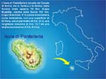
The Geography of PantelleriaThe Geographical Coordinates are:
Lat: 36.80º
N Long: 12.00º E
Pantelleria have an area of 83 sq. km., a length of 14 km, a
width of 9 km; its perimeter measures 51,5 km and its maximum
height is 836 metres above sea level.
It has a typical Mediterranean climate with hot summers and mild
winters.
The annual mean temperature is 18 °C ( 64°F) Precipitations are
poor since constant winds keep the sky free of clouds.
The heights of the main hills of Pantelleria are:
| Monte Gibele |
700 m. |
| Kuddia Mida |
591 m. |
| Kuddia Attalora |
560 m. |
| Fossa del Russo |
481 m. |
| Kuddia del Moro |
444 m. |
| Kuddia del Gallo |
441 m. |
| Kuddia Patite |
429 m. |
| Kuddia Randazzo |
416 m. |
| Kuddia Gibele |
396 m. |
| Gelfiser |
394 m. |
| Kuddia Sciuveki |
389 m. |
| Kuddia Valletta |
347 m. |
| Kuddia Muèggen |
345 m. |
| Kuddia Gelkhamar |
289 m. |
| Sant'Elmo |
245 m. |
| Kuddia Maccotta |
233 m. |
| Kuddia Gadir |
155 m. |
| Kuddia Bruciata |
118 m. |
| Kuddie Rosse |
36 m. |
Distance from Pantelleria to:
| Capo Bon (TUNISIA) |
45 mgl |
| Cagliari |
200 mgl |
| Marettimo |
68 mgl |
| Favignana |
68 mgl |
| Marsala |
62 mgl |
| Mazara del Vallo |
58 mgl |
| Sciacca |
68 mgl |
| Porto Empedocle |
81 mgl |
| Licata |
97 mgl |
| Gela |
112 mgl |
| Scoglitti |
123 mgl |
| Capo Passero |
160 mgl |
| Malta |
130 mgl |
| Lampedusa |
100 mgl |
|